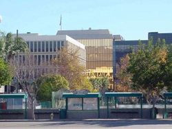
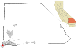
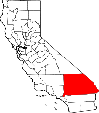
Chino, California
| City of Chino | |||
|---|---|---|---|
| — City — | |||
|
|||
 |
|||
| Coordinates: | |||
| Country | United States | ||
| State | California | ||
| County | San Bernardino | ||
| Incorporated | 1910 | ||
| Government | |||
| - Type | Council-Manager | ||
| - Mayor | Dennis Yates | ||
| - City Manager | Pat Glover | ||
| Area | |||
| - Total | 21.1 sq mi (54.5 km2) | ||
| - Land | 21.1 sq mi (54.5 km2) | ||
| - Water | 0.0 sq mi (0.0 km2) | ||
| Elevation | 728 ft (222 m) | ||
| Population (2000) | |||
| - Total | 69,732 (city proper) | ||
| - Density | 455.6/sq mi (175.9/km2) | ||
| Time zone | PST (UTC-8) | ||
| - Summer (DST) | PDT (UTC-7) | ||
| ZIP code | 91708, 91710 | ||
| Area code(s) | 909 | ||
| FIPS code | 06-13210 | ||
| GNIS feature ID | 1660477 | ||
| Website | www.cityofchino.org | ||

Chino is a city in San Bernardino County, California, United States. It is located in the western end of the Riverside-San Bernardino Area and it is easily accessible via the Chino Valley (71) and Pomona (60) freeways.
Chino is bounded by Chino Hills to the west, unincorporated San Bernardino County (near Montclair) to the north, Ontario to the northeast, unincorporated San Bernardino County to the southeast, and unincorporated Riverside County to the south. The population was 67,168 at the 2000 census, but as of 2007 the population of Chino has grown to 82,830.
Chino and its surroundings have long been a center of agriculture and dairy farming, serving the considerable demands for milk products in Southern California and much of the southwestern United States. Chino’s rich agricultural history dates back to the Spanish land grant forming Rancho Santa Ana del Chino. The area specialized in orchard, row crops and dairy. Downtown Chino is home to satellite branches of the San Bernardino County Library and Chaffey Community College, the Chino Community Theatre, the Chino Boxing Club and a weekly Farmer's Market. In 2008 the City of Chino was awarded the prestigious "100 Best Communities for Youth" award for the second time in three years[1]. Chino hosted shooting events for the 1984 Summer Olympics at the Prado Olympic Shooting Park in the Prado Regional Park. Two California state prisons for adults (California Institution for Men and California Institution for Women), as well as the Heman G. Stark Youth Correctional Facility, lie within the city limits.[2]
The land grant on which the town was founded was called Rancho Santa Ana del Chino. Santa Ana is Spanish for Saint Anne, but the exact meaning of "Chino" has been explained in different ways. One explanation is that the "Chino," (curly-haired person or mixed-race person) was the chief of the local Native American village.[3] The president of the Chino Valley Historical Society, drawing on US Civil War-era letters, designates the "curl" referenced in the toponym as that at the top of the grama grass that abounded in the valley.[4]
Contents |
History
The first inhabitants of Chino in modern times were the Tongva, who had a settlement called Wapijangna in the Santa Ana River watershed. Some residents of Wapijanga were baptized at Mission San Gabriel, which was established in 1771. The Spanish crown claimed the land, at least nominally, until Mexican independence was finalized and possession fell to the Mexican government.
Some twenty years later, Mexican governor of Alta California Juan Bautista Alvarado granted Rancho Santa Ana del Chino to Antonio Maria Lugo of the prominent Lugo family. Two years later, his successor, Governor Micheltorena, granted an additional three leagues to Lugo's son-in-law Isaac Williams, who took charge of the rancho. Williams kept large quantities of horses and cattle, which attracted the envy of raiding Native Americans as well as unscrupulous whites. One of the latter was James Beckwourth, who, in 1840, posed as an otter hunter and stayed at Rancho Chino to determine the location of the area's animals, which he then reported to Walkara, the Ute mastermind of the raids.
Early in the Mexican-American War, the Battle of Chino took place at Williams' rancho. The battle ended prior to the arrival of the Mormon Battalion, dispatched on behalf of the United States, who instead labored in the rancho's agricultural harvest and constructed a grist mill.
During the California Gold Rush, the rancho was a popular stopover for travelers, and in the mining fury, coal was discovered there. In 1850, California was admitted to the union, and the process of separating privately-held lands from the public domain began. The Williams claim to the Chino Rancho was patented in 1869.
Richard Gird was the next owner of the Rancho. Beginning in 1887, his land was subdivided and laid out. It became the 'Town of Chino,' and incorporated into a city in 1910.[5]. Sugar beets, corn, and alfalfa were raised there.
Many historical elements of Chino were frantically demolished for speculation. A large house was demolished to build 'Value Fair' now a defunct shopping area on the corner of Walnut and Central. The City Central—Old Town, was demolished for the Courts, Police and City Hall, and now faces obsolescence as the Courts, Police and City Hall look for better places. The lower area of the City has always been prone to flooding, and Prado Dam areas are hazardous in times of rain. Race relations reached City wide proportions in the late 60s with many patrol cars burned. Chicano versus White and Chicano versus Black racial animosities have always been present since the late 60s in the Chino region.
In the 1970s, Chino developed into a small suburban city, forming the western anchor of the Inland Empire region, and now the city's development has gradually taken on a more middle-class character. There are still many industrial areas as well as farm animals such as goats and chickens. According to the 2004 FBI UCR, the city had about 3.6 violent crimes per 1,000 population, which is typical for an American suburb, and its property crime was actually below average.
Education
Chino has 9 elementary schools:
- El Rancho Elementary (Closed in 2008-2009 School Year)
- Alicia Cortez Elementary
- Newman Elementary
- E.J. Marshall Elementary
- Dickson Elementary
- Anna Borba
- Howard Cattle
- Richard Gird (Closed in 2008-2009 School Year)
- Edwin Rhodes
Chino has 3 junior high schools:
- Briggs Junior High School
- Ramona Junior High School
- Magnolia Junior High School
Chino has 3 high schools:
- Don Antonio Lugo High School
- Buena Vista High School
- Chino High School
Chino is serviced by a satellite center of Chaffey College, a community college.
Geography
Chino is located at (34.017765, -117.689990)[6]. According to the United States Census Bureau, the city has a total area of 54.5 km² (21.1 mi²). 54.5 km² (21.0 mi²) of it is land and 0.05% is water.
- Chino is a suburb in San Bernardino County, located 33 miles (53 km) from the county seat, San Bernardino.
- Los Angeles, 35 miles (56 km)
- Riverside, 26 miles (42 km)
- Santa Ana, 30 miles (48 km)
- Anaheim, 24 miles (39 km)
Demographics
| Historical populations | |||
|---|---|---|---|
| Census | Pop. | %± | |
| 1910 | 1,444 |
|
|
| 1920 | 2,132 | 47.6% | |
| 1930 | 3,118 | 46.2% | |
| 1940 | 4,204 | 34.8% | |
| 1950 | 5,784 | 37.6% | |
| 1960 | 10,305 | 78.2% | |
| 1970 | 20,411 | 98.1% | |
| 1980 | 40,165 | 96.8% | |
| 1990 | 59,682 | 48.6% | |
| 2000 | 67,168 | 12.5% | |
| Est. 2007 | 82,830 | 23.3% | |
As of the census[7] of 2000, there were 67,168 people, 17,304 households, and 14,102 families residing in the city. The population density was 1,232.0/km² (3,190.5/mi²). There were 17,898 housing units at an average density of 328.3/km² (850.2/mi²). The racial makeup of the city was 55.70% White, 7.82% African American, 0.93% Native American, 4.92% Asian, 0.21% Pacific Islander, 25.56% from other races, and 4.86% from two or more races. Hispanic or Latino of any race were 47.39% of the population.
There were 17,304 households out of which 47.3% had children under the age of 18 living with them, 62.5% were married couples living together, 12.9% had a female householder with no husband present, and 18.5% were non-families. 14.1% of all households were made up of individuals and 5.2% had someone living alone who was 65 years of age or older. The average household size was 3.43 and the average family size was 3.77.
In the city the population was spread out with 28.5% under the age of 18, 12.3% from 18 to 24, 34.2% from 25 to 44, 19.2% from 45 to 64, and 5.9% who were 65 years of age or older. The median age was 31 years. For every 100 females there were 124.3 males. For every 100 females age 18 and over, there were 133.1 males.
The median income for a household in the city was $55,401, and the median income for a family was $59,638. Males had a median income of $35,855 versus $30,267 for females. The per capita income for the city was $17,574. About 6.3% of families and 8.3% of the population were below the poverty line, including 10.0% of those under age 18 and 8.5% of those age 65 or over.
Politics
In the state legislature Chino is located in the 29th Senate District, represented by Republicans Bob Huff, and in the 61st Assembly District, represented by Democrat Norma Torres. Federally, Chino is located in California's 42nd congressional district, which has a Cook PVI of R +10[8] and is represented by Republican Gary Miller.
Attractions
- Planes of Fame is an air museum at Chino Airport.
- Yanks Air Museum is another air museum at Chino Airport.
- Flo's Airport Cafe, also at Chino Airport.
Chino in popular culture
The term Chino is often mentioned in music and television but usually in reference to the prison located there and not the city.
- In the television series The O.C., the main character, Ryan Atwood, is a tough kid from Chino adopted into a wealthy family in Newport Beach. In the series, Chino is depicted as a dreary slum. The negative depiction of Chino led to complaints from city officials that Chino was being depicted as a "dirtbag town."[9]
- Chino was used as a location during the filming of the movie Back to the Future, particularly the farmland setting when Marty first travels back in time to 1955.
- Chino is mentioned in Alejandro Escovedo's song Smoke, off the album Real Animal.
- Chino is mentioned in Robert Hunter's song Friend of the Devil, performed by the Grateful Dead.
- In the song "Murder Was the Case", by rapper Snoop Dogg, he mentions in the song, "I'm on my way to Chino, rollin' on tha grey goose".
- California governor Arnold Schwarzenegger, while giving a speech in Chico, CA, referred to that city as "Chino".
- In the song Original Prankster by The Offspring.
- Professional wrestler John Morrison claimed in a promo that when he took his shirt off in Chino, the spontaneous screaming from all the young ladies in the city registered as a 5.4 on the Richter Scale.
- The Mountain Goats have written several songs about Chino. The song Going to Chino applauds the city for its rich agriculture and accredited medical care.
External links
References
- ↑ Chino Amongst the "100 Best" Again Accessed 13 November 2008
- ↑ Mayor Takes a Stand on Prison Population. City of Chino, 14 August 2006. Accessed 29 November 2007.
- ↑ Gudde, Erwin Gustav; William Bright (1998). California Place Names. Berkeley: University of California Press. pp. 77. ISBN 0-520-24217-3. http://books.google.com/books?id=Kqwt5RlMVBoC.
- ↑ Jones, Kay (2009-09-03). "Why We Celebrate the 1st Territorial Capital Days in Chino". Chino Valley eNews. http://www.chinovalleyenews.com/chino-valley/why-we-celebrate-the-1st-territorial-capital-days-in-chino. Retrieved 2009-12-01.
- ↑ Dubois, Phil; Allen P. McCombs. "Chino Police History". Chino Police Department Website. Chino PD. http://www.chinopd.org/Overview%20pages/Chino%20PD%20History.htm. Retrieved 2009-12-01.
- ↑ "US Gazetteer files: 2000 and 1990". United States Census Bureau. 2005-05-03. http://www.census.gov/geo/www/gazetteer/gazette.html. Retrieved 2008-01-31.
- ↑ "American FactFinder". United States Census Bureau. http://factfinder.census.gov. Retrieved 2008-01-31.
- ↑ "Will Gerrymandered Districts Stem the Wave of Voter Unrest?". Campaign Legal Center Blog. http://www.clcblog.org/blog_item-85.html. Retrieved 2008-02-10.
- ↑ Straight, Susan (2003-09-09). "Dissed by "The O.C."". Salon. http://dir.salon.com/story/mwt/feature/2003/09/09/oc/index.html.
|
||||||||||||||||||||
|
|||||||||||||||||||||||||